Core Service
3D Laser Scanning & Point Cloud Delivery
The fastest and most accurate method for capturing existing conditions. We scan your building and deliver clean, registered point cloud data in the format your design software requires, and you keep full control of the modelling.
At a Glance
- Scan accuracy
- Deviation under 6 mm at 10 m range
- Delivery formats
- E57 · RCP/RCS · XYZ (others on request)
- Turnaround
- 3–5 working days from site visit
- Included
- Registration, cleaning, 360° panoramas, control report
- Coverage
- London & Greater London (further afield by arrangement)
How 3D Laser Scanning Works
The laser scanner is positioned at multiple locations throughout and around the building. At each position, it performs a 360° sweep, measuring the distance to every surface within range. Each measurement is recorded as a point with precise X, Y, Z coordinates, along with colour information from an integrated HDR camera. All scan positions are then aligned (registered) into a single unified coordinate system.
What Is a Point Cloud?
A point cloud is a dataset of millions of precisely measured 3D coordinates, captured by laser scanners. Each point records the exact position of a surface in space: walls, floors, ceilings, windows, doors, beams, columns, and every visible architectural element.
When you import a point cloud into your design software, you see a detailed 3D representation of the building that you can measure, section, and model over with complete confidence in the accuracy of the underlying data.
Real Examples from Our Projects
Real point cloud data from our London projects. Click any image to view it full size.
 Section
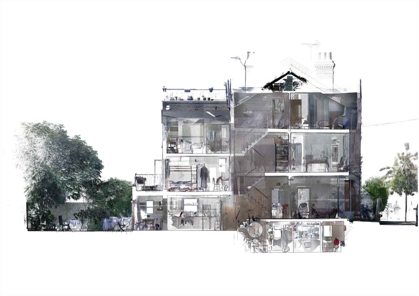
Residential Section
A section cut straight through the point cloud of a London townhouse, with every floor, stair and room visible.
 Elevation
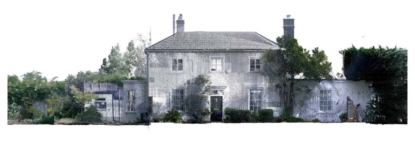
Facade Elevation
True-to-life orthographic elevation taken directly from registered scan data.
 Interior
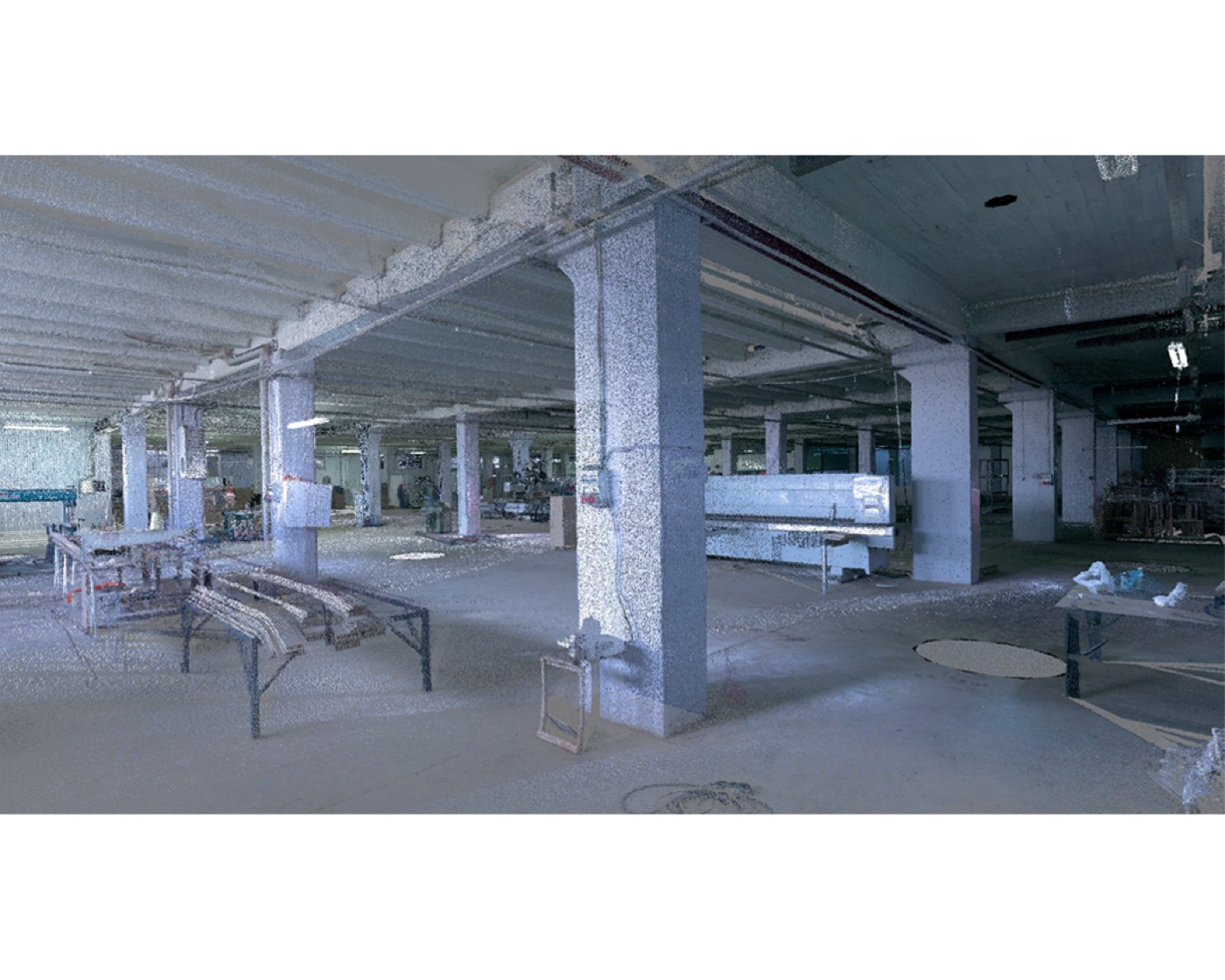
Commercial Interior
Full-colour interior scan of an industrial unit, ready for measurement and modelling.
Point Clouds in Motion
Short clips from our YouTube channel showing real scan data from London projects.
Why Choose Point Cloud Delivery?
- You control the modelling: receive the raw measured data and work directly in your own software, at your own pace, to your own standards.
- Multiple uses from one dataset: floor plans, sections, elevations, BIM modelling, clash detection, visualisation, and heritage documentation. One survey, unlimited applications.
- Faster and more cost-effective: we deliver the processed scan data without the additional drawing or modelling phase.
- Permanent digital archive: a complete, measurable digital record of the building at the time of survey.
Supported Formats & Software
Autodesk Revit
We deliver RCP files processed through Autodesk ReCap. Import directly into Revit as a linked point cloud and begin modelling with full measured accuracy. Ideal for scan-to-BIM workflows.
ArchiCAD
We provide E57 format, ArchiCAD's natively supported point cloud format. Import via File > Interoperability > Import Point Clouds. We optimise file sizes so your project runs smoothly.
Note: Most UK surveyors only deliver Revit-compatible formats, leaving ArchiCAD users to handle conversion themselves. We deliver data that works straight out of the box.
SketchUp
Point cloud data in E57 format, compatible with SketchUp extensions like Undet for SketchUp or Trimble Scan Explorer.
AutoCAD
RCP files for linking point clouds directly in AutoCAD. Take measurements, create cross-sections, and trace 2D drawings from the scan data.
What Is Included
Our Process
Project Brief
You tell us about the building and which software you use. We provide a fixed-price quote promptly.
Site Survey
Our surveyor captures every room, façade, and accessible area with millions of measured points. Most residential buildings are completed in a single visit.
Data Processing
Scans are registered into a single coordinate system, cleaned of noise, and exported in your requested format.
Delivery
Receive your point cloud data within 3-5 working days, ready to import and start working.
How Much Does a Point Cloud Survey Cost?
Every building is different, so we price each project individually. Your quote depends on five factors:
- Building size: total floor area to be captured
- Number of floors: including basements and roof spaces
- Scope: interior only, exterior only, or both
- Point density: standard density suits most design work; higher density for heritage detail
- Access & complexity: occupied buildings, restricted areas, or scaffolding requirements
Because there is no drawing or modelling phase, point-cloud-only delivery is our most cost-effective service: you pay for the survey, not for work your own team can do better. Every project receives a fixed-price quote before we arrive on site, with no hidden fees.
Typical Applications
- Refurbishment & extension design
- Interior design fit-outs
- Planning applications
- Heritage & conservation documentation
- As-built verification
- Facility management
Coverage Area
We are based in London and carry out most of our work across Greater London. Projects further afield are considered on request. Contact us with your project location.
Frequently Asked Questions
A typical residential property generates 500MB to 2GB. We can adjust point density to balance detail with file performance in your software.
Yes. We can deliver in multiple formats at no extra cost. For example, RCP for Revit and E57 for a consultant working in ArchiCAD.
Our laser scanners achieve deviation accuracy under 6mm at 10m range, suitable for architectural design, planning, and refurbishment work.
Point cloud delivery gives you the raw 3D scan data. A measured building survey adds 2D CAD drawings produced from that data. Point cloud delivery is faster and more cost-effective if you do the modelling yourself.
In ArchiCAD, go to File > Interoperability > Import Point Clouds and select the E57 file we provide. We provide files optimised for ArchiCAD's performance limits.
Ready to get started?
Tell us about your project and receive a fixed-price quote promptly.